
The National Hurricane Center upgraded a Gulf of Mexico depression to Tropical Storm Isaias in its 4 a.m. CDT advisory on Wednesday, Oct. 7, and forecasters now expect the system to strengthen rapidly into a hurricane as it approaches the northern Gulf Coast on Friday. The storm's formation has already nudged oil markets higher and prompted the first operator precautions offshore, even as the official NHC track carries below-average confidence this far out.
What the Hurricane Center Is Forecasting
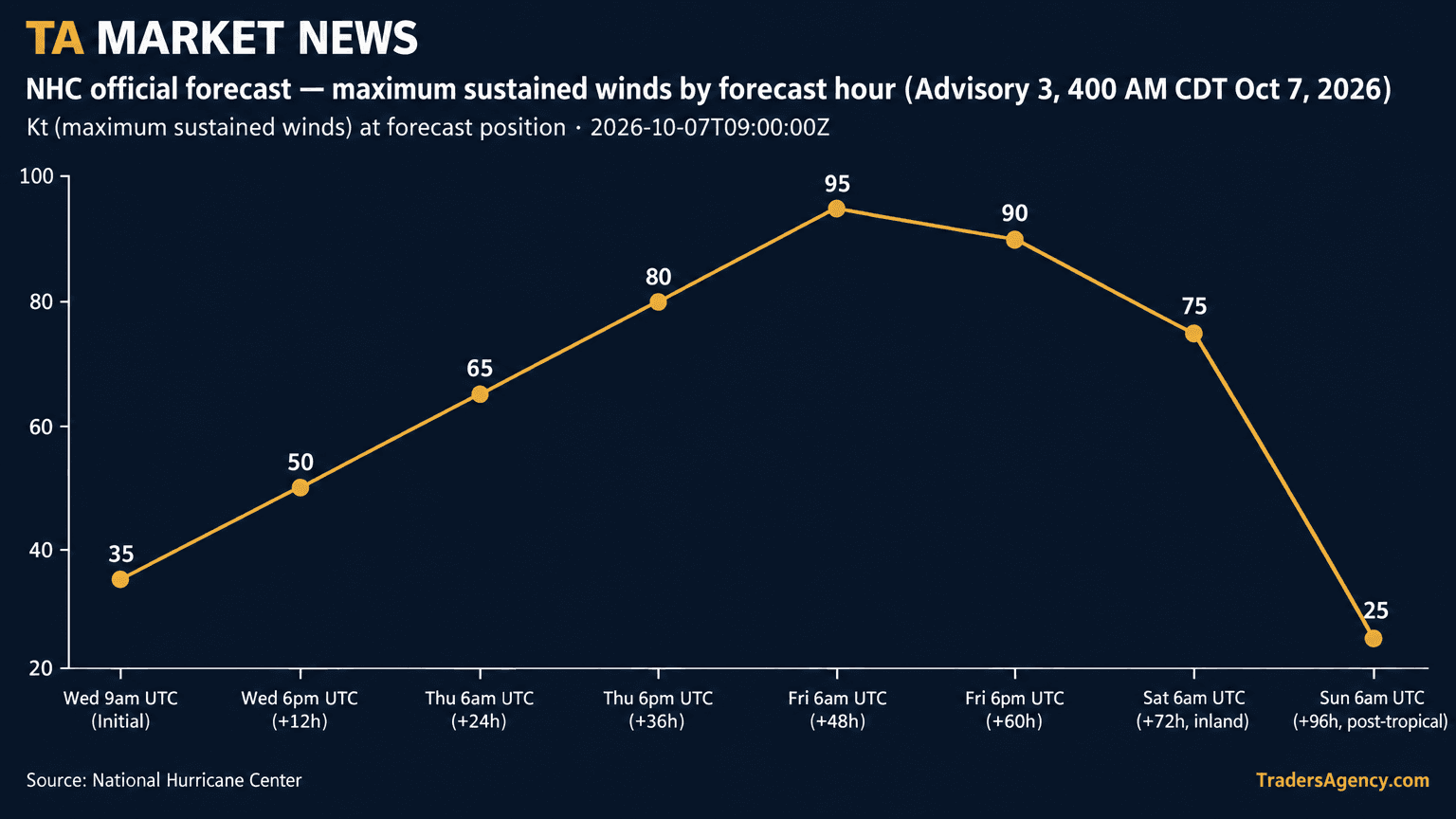
In Advisory Number 3, the National Hurricane Center said the depression had become Tropical Storm Isaias and is forecast to rapidly strengthen over the next couple of days. On the forecast track, Isaias is expected to pass north of the Yucatan Peninsula on Thursday and approach the U.S. northern Gulf Coast on Friday. The agency's official forecast positions and intensities show maximum sustained winds climbing from 35 knots (40 mph) at the 0900 UTC initial time Wednesday to 65 knots (75 mph, hurricane strength) at 0600 UTC Thursday, then 95 knots (110 mph) at 0600 UTC Friday, when the center is projected near 25.5N, 88.5W, according to the NHC forecast discussion. The agency's 72-hour point, valid 0600 UTC Saturday with the system inland, still shows 75-knot (85 mph) winds.
Early projections place landfall somewhere between eastern Louisiana and the western Florida Panhandle, and CNBC reported that the hurricane center's initial projections described that same stretch of coast. Local station WALA FOX10 said the current NHC cone stretches from southeast Louisiana eastward toward roughly Destin, Florida, keeping Mobile and Pensacola in the area that needs to monitor the track. WALA added that Friday is now the critical day for the Mobile-Pensacola area, with impacts potentially beginning Thursday night, and that the National Weather Service office in Mobile expects the system to approach the northern Gulf Coast Friday as a hurricane.
NHC forecaster Papin flagged that track confidence remains below average, noting in the official discussion that AI-model guidance sits on the east side of the guidance envelope while physics-based models sit on the west side, and that the latest track represents an eastward shift from the previous forecast cycle. The agency is urging residents from Louisiana to the Florida Panhandle to monitor updates and have a hurricane plan in place given what it called an increasing risk of dangerous wind and storm surge impacts along the northern Gulf Coast.
Rainfall, Wind Field and Storm Structure
The NHC's rainfall outlook calls for 3 to 6 inches, with localized totals up to 10 inches, from far southeastern Louisiana to the Florida Panhandle between Friday and the weekend, plus 1 to 3 inches, locally up to 5 inches, across much of the Southeast as far north as the Tennessee Valley and the Carolinas. The forecast discussion also warns that vertical wind shear will increase dramatically in the final 24 hours before the cyclone reaches the northern Gulf Coast, and that Isaias will be interacting with a short-wave trough near landfall, which forecasters say is likely to expand the wind field and cause rain and wind impacts to extend far from the center on the storm's eastern side. The agency described the storm's short-term environment as rather favorable, citing very warm 30-31 C sea-surface temperatures, plenty of deep-layer moisture and light to moderate shear of 10 to 15 knots diagnosed by SHIPS guidance. Air Force Reserve and NOAA Hurricane Hunter reconnaissance missions were scheduled to sample the tropical storm later Wednesday, according to the discussion.
Offshore Production and Refining Exposure
The Bureau of Safety and Environmental Enforcement's Marine Minerals Administration said that, as of 11:30 a.m. CDT Tuesday, Oct. 6, operators had shut in 9.24% of Gulf of America oil production (185,120 barrels per day) and 3.36% of gas production (72 million cubic feet per day), while reporting zero platforms evacuated, zero rigs evacuated and no dynamically positioned rigs moved off location. The agency cautioned that the survey reflects one company's reports as of that time and said it will continue to update the evacuation and shut-in statistics at 1 p.m. CDT each day. Read against that caveat, the tally should be treated as a partial snapshot rather than a full industry count, and it may change as additional operators report ahead of the storm's approach.
Bloomberg, cited by the Business Times, reported that Chevron was evacuating non-essential staff from its Gulf of Mexico platforms but had made no adjustments to output as of that report. The same Bloomberg item noted that current forecasts at the time put the storm east of major offshore oil and natural gas production south of Louisiana and Texas, though it cautioned that disruptions remain possible depending on the storm's eventual path and size.
Reuters, via WTVB, reported that offshore areas in the storm's path produce 15% of U.S. crude oil and 5% of the country's natural gas, and that the storm could affect six refineries. Gulf state refineries account for roughly 50% of the national refining capacity of 18.2 million barrels per day, according to the same Reuters report.
Market Reaction
Oil prices advanced as the storm developed, according to both Reuters (via WTVB) and Bloomberg (via the Business Times), with Bloomberg tying the move in part to vessel attacks challenging rising Hormuz shipments. KCM Trade chief analyst Tim Waterer, quoted by Reuters, called the storm an "unwelcome complication for crude, raising the prospect of production and refining disruptions at a time when the market already has enough supply-side headaches." Reuters also reported that market sources citing American Petroleum Institute data said U.S. crude stocks fell by 2.09 million barrels in the week ended Oct. 2; Bloomberg put the API estimate at a contraction of 2.1 million barrels.
Bottom line: the storm's market relevance depends on how much Gulf production and refining capacity ends up in its path. Reuters reported that the offshore areas in the path produce 15% of U.S. crude oil and 5% of the country's natural gas and that six refineries could be affected, with Gulf state refineries accounting for about 50% of national capacity of 18.2 million barrels per day, while BSEE's latest tally showed 9.24% of Gulf oil output shut in and no platforms evacuated as of Tuesday morning. Interpreting those figures together, the scale of any supply disruption remains unresolved, because the NHC itself flags below-average track confidence and an eastward shift in its latest cycle. CNBC reported that Isaias is expected to become the first hurricane of an Atlantic season that has been unusually quiet because of a strong El Niño, while Pacific activity has run above average.
DISCLAIMER: Traders Agency does not offer financial advice. The information provided is for educational purposes only and should not be considered financial advice. Traders Agency is not responsible for any financial losses or consequences resulting from the use of the information provided. Trading carries inherent risks and may not be suitable for all individuals. You are advised to conduct your own research and seek personalized advice before making any investment decisions, recognizing the potential risks and rewards involved.
- CNBC Top News: Tropical Storm Isaias U.S. Gulf Coast · accessed Oct 7, 2026
- National Hurricane Center: Tropical Storm Isaias Public Advisory · accessed Oct 7, 2026
- National Hurricane Center: Tropical Storm Isaias Forecast Discussion · accessed Oct 7, 2026
- Bureau of Safety and Environmental Enforcement: MMA Monitors Gulf of America Oil and Gas Activities in Response to Invest 92L · accessed Oct 7, 2026
- Reuters via WTVB: Oil gains as US storm and Houthi air strikes threaten supply · accessed Oct 7, 2026
- Bloomberg via The Business Times: Oil advances as vessel attacks challenge rising Hormuz shipments · accessed Oct 7, 2026
- WALA FOX10 News: Isaias taking aim on the northern Gulf: What Mobile-Pensacola can expect · accessed Oct 7, 2026
- CIMSS Satellite Blog, University of Wisconsin–Madison: Tropical Depression Nine forms in the Gulf of Mexico, and is forecast to intensify to Tropical Storm (or possibly Hurricane) Isaias · accessed Oct 7, 2026
See more from Traders Agency on Google
Make us a preferred source and our market analysis will appear more prominently in your Google Search, Top Stories, and AI results.
Add to Preferred Sources